Yes, I decided to call it “Southern Ireland”, because I doubt many people outside of Europe will know which one of the two Irelands is the “Republic of Ireland”.
Wow, that dam between northern Ireland and the Republic of Ireland has really come along in this better map. United Kingdom is great Britain and northern Ireland, for reference.
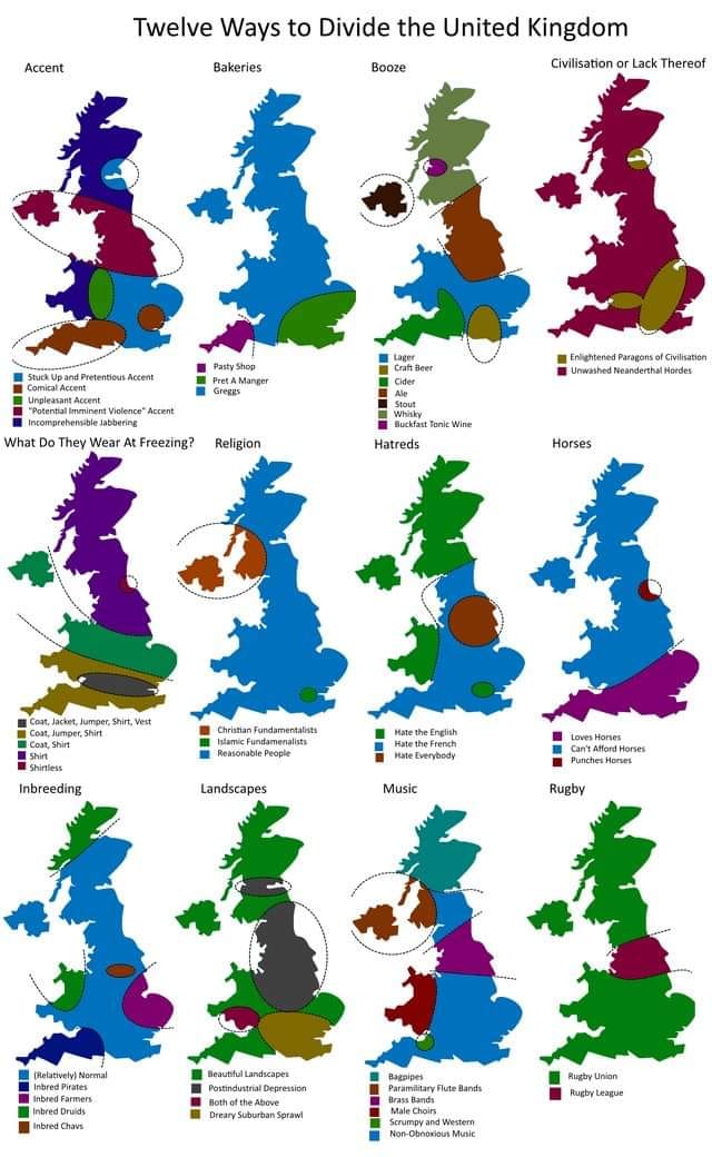
They rotated it slightly to get the south coast more horizontal and binned off most islands (the Shetlands and Orkneys I can understand but the Isle of Man wasn’t in the way).so they could pack more into the space.

I was very confused by the shape of this United Kingdom. For reference, this is what it + the non-UK part of Ireland actually looks like:
I’m guessing, they left out all the islands, but even then, it still doesn’t look terribly accurate to me, so no idea…
Edit: Added clarification about Southern Ireland.
Careful what you call United Kingdom! They left out Ireland because it’s not part of UK
Ah yeah, good point. I was very confused by Southern Ireland missing on their map, too, but my comment made it sound like that’s part of the UK.
You also want to be careful using terms like ‘Southern Ireland’. Northern Ireland is a thing, and the Republic of Ireland is a thing…
Yes, I decided to call it “Southern Ireland”, because I doubt many people outside of Europe will know which one of the two Irelands is the “Republic of Ireland”.
I did look up beforehand, if I’m allowed to say “Southern Ireland” without being crucified and Wikipedia said
yesmaybe: https://en.wikipedia.org/wiki/Southern_IrelandWow, that dam between northern Ireland and the Republic of Ireland has really come along in this better map. United Kingdom is great Britain and northern Ireland, for reference.
They rotated it slightly to get the south coast more horizontal and binned off most islands (the Shetlands and Orkneys I can understand but the Isle of Man wasn’t in the way).so they could pack more into the space.
Check your mailbox